
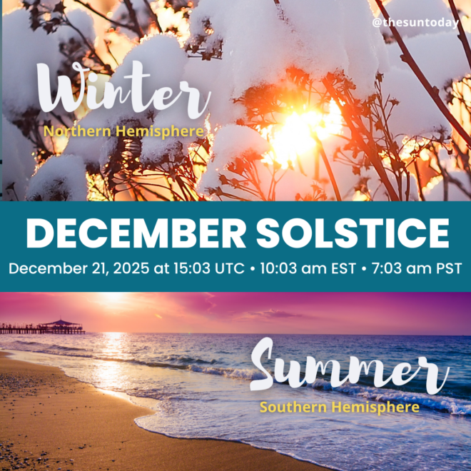
It is the 2021 December Solstice!
[ycd_countdown id=15609]
15:58 GMT • 10:58 am EST • 9:58 am CST • 8:58 MST • 7:58 am PST
Convert Your Timezone
A new season is upon us! Depending upon where you live:
 OR
OR 
The December solstice is the beginning of winter for the northern hemisphere and summer for the southern hemisphere. It occurs between December 20th and 23rd every year.
For 2021 it occurs on Tuesday, December 21st at 15:58 UTC
(10:58 am EST on Tuesday, December 21st).
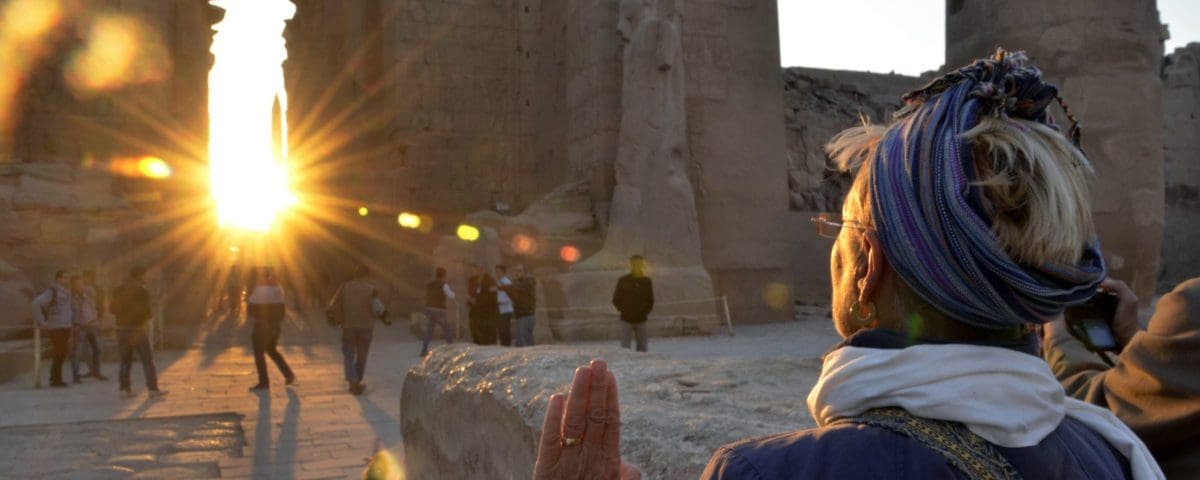
Watch the first Winter sunrise at Stonehenge
For some solstice excitement, or at least a little connection to how some ancient people focused on the sun by watching this special sunrise, turn into the live feed from Stonehenge. It’s the first sunrise after the Winter solstice.
- The coverage starts on Wednesday, December 22, 2021
- At approximately 07:25 UTC (2:25 am EST, 11:25 pm PST) until 08:55 UTC
- Sunrise is at 8:09 UTC (3:09 am EST, 12:09 am PST)
- You can convert from UTC to your local time by simply Googling it (e.g. “8 UTC in EST”) or try an online tool.
It’s official! Happy December Solstice! Seasons greetings! May all your days be sunny & bright!
It happened 15:58 GMT • 10:58 am EST • 9:58 am CST • 8:58 MST • 7:58 am PST! pic.twitter.com/ShtmJ4db5A
— C. Alex Young, Ph.D. (@TheSunToday) December 21, 2021
What are solstices?
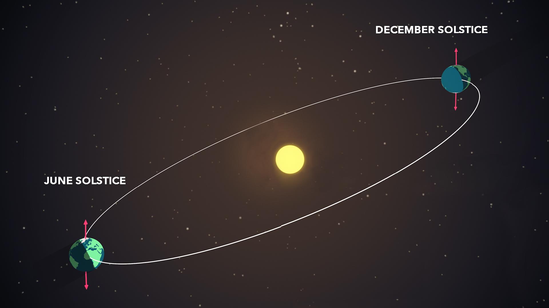
There are two solstices in a year, the June solstice (between June 20-22) and the December solstice (between December 20-23).
On the June solstice, the Sun reaches its highest point in the sky for an observer at the North Pole. On the December solstice, the Sun reaches its highest point in the sky for an observer at the South Pole. Solstices also mark the change from fall to winter or spring to summer.
The solstices happen because of the tilt of Earth’s axis of rotation with respect to its orbital path around the Sun. The axis of rotation is an imaginary line drawn straight through Earth connecting the North Pole to the South Pole. This line is tilted 23.5° from Earth’s orbital path around the Sun. This means that the Sun’s light does not hit the Earth evenly at a particular latitude above and below the equator. This tilt is the cause of Earth’s seasons.
During the solstices, Earth reaches a point where its tilt is at the greatest angle to the plane of its orbit, causing one hemisphere to receive more daylight than the other. (NASA/Genna Duberstein)
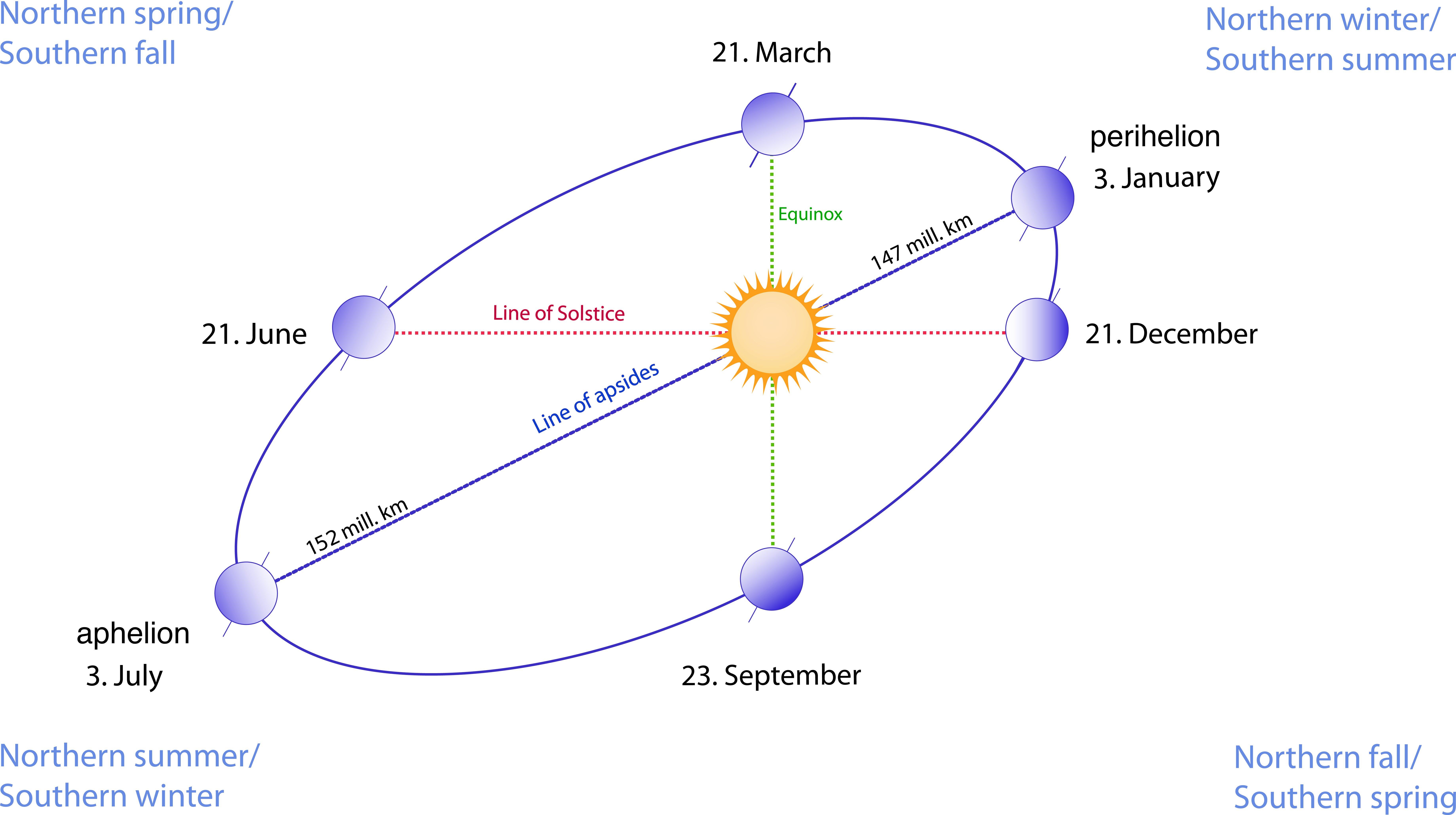
This diagram shows the relation between the line of solstice and the line of apsides of Earth’s elliptical orbit. The orbital ellipse (with eccentricity exaggerated for effect) goes through each of the six Earth images, which are sequentially the perihelion (periapsis—nearest point to the Sun) on anywhere from 2 January to 5 January, the point of March equinox on 20 or 21 March, the point of June solstice on 20 or 21 June, the aphelion (apoapsis—the farthest point from the Sun) on anywhere from 4 July to 7 July, the September equinox on 22 or 23 September, and the December solstice on 21 or 22 December. CREDIT
This means that the Sun’s light does not hit the Earth evenly at a particular latitude above and below the equator. This tilt is the cause of Earth’s seasons.
The equator is an imaginary line drawn right around Earth’s middle, like a belt. It divides Earth into the Northern and the Southern Hemispheres.
The imaginary lines around Earth that are parallel to the Equator are called lines of latitude. They are numbered from 0° to 90°. The one at 0° is the equator itself. The higher the number, the farther north (if it’s a + number) or south (if it’s a − number).
Because of Earth’s tilt is 23.5° the latitudes of +23.5° and −23.5° are special and have special names. The one in the Northern Hemisphere, +23.5° latitude, is called the Tropic of Cancer. The one in the Southern Hemisphere, − 23.5° latitude, is called the Tropic of Capricorn.
These are the latitudes where the Sun is directly overhead at noon once a year. In the Northern hemisphere, on the Tropic of Cancer, that is the June Solstice. In the Southern Hemisphere, on the Tropic of Capricorn, that is the December Solstice. These solstice days are the days with the most (for Summer) or fewest (for Winter) hours of sunlight during the whole year.

The Sun is directly overhead at “high-noon” on December Solstice at the latitude called the Tropic of Capricorn.
Science communicator Dr. James O’Donoghue creates amazing visuals. He created two visuals to illustrate the reasons for the seasons, solstices, and equinoxes.

A fun note: It’s all about geometry!
The most important aspect of the seasons and the light (and heat) received by different parts of Earth at different times of the year all comes down to geometry. That is the geometry of a sphere.
The Earth is a sphere that is tilted as it orbits the sun. So depending on the tilt and the time of the year different parts of Earth receive different amounts of light and different amounts of heat.
Another thing to think about for this geometry is the location of the objects that we can see in the night sky (or the sky near sunset and sunrise).
Something that is a bit counter to our perspective and our senses is that we are all standing on a globe and our perspective looking to the sky depending upon where we are on the globe. A great way to see this is to follow the planets visible at night.
If you have a chance, maybe even view them from the Northern and Southern hemispheres, and compare what you see. That second part can be a bit difficult but we can use tools to help us see the differences.
The planets orbit in a plane around the sun and the imaginary line they follow is called the ecliptic. Earth is tilted on its axis of rotation so the ecliptic is also tilted.
The stars which a super far away rotate with us through the night and the planets follow the ecliptic (some planets are slight off the ecliptic but they basically follow it).
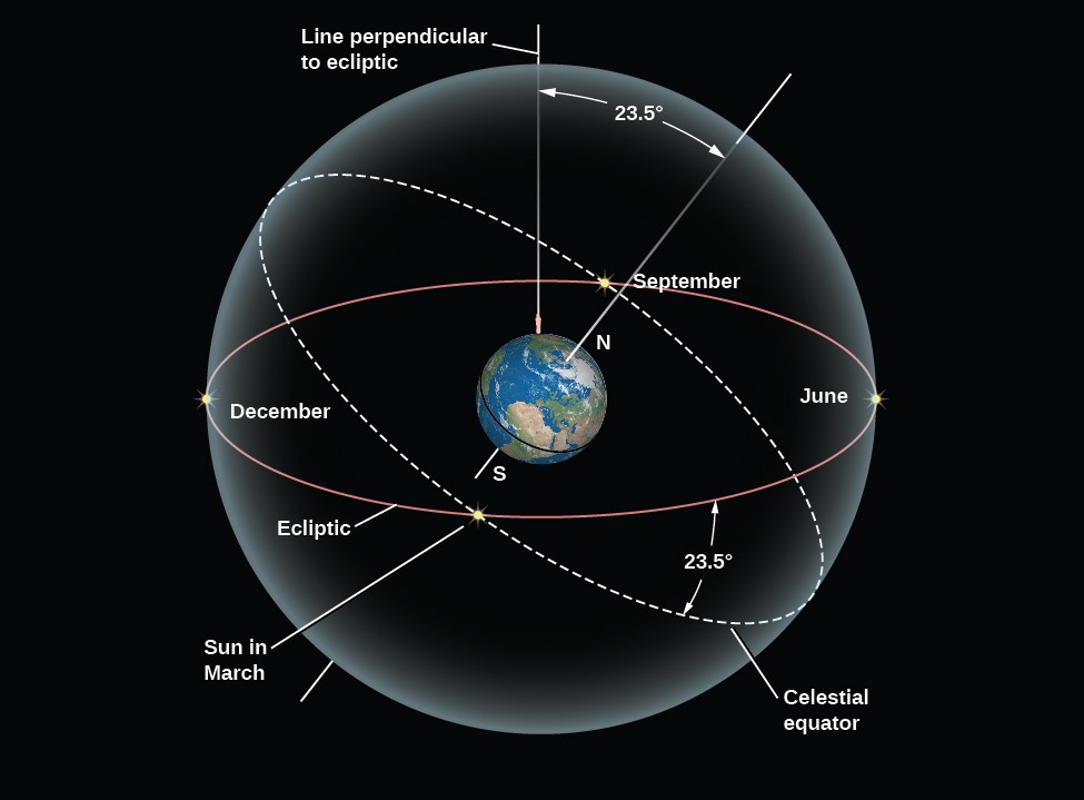
The Celestial Tilt. The celestial equator is tilted by 23.5° to the ecliptic. As a result, North Americans and Europeans see the Sun north of the celestial equator and high in our sky in June, and south of the celestial equator and low in the sky in December. (credit: https://courses.lumenlearning.com/astronomy/chapter/the-sky-above/)
The moon’s motion in the sky is even more complex because the moon itself has a separate motion above and below Earth’s rotation of 5 degrees or more than 10 moons in size above and below the rotation plane of Earth (the moon is about a half a degree in size so 5 degrees is 10 moons).
#lookup and Do Your Own Observations!
We can take a look at where in the sky planets are visible from anywhere on Earth using the TimeandDate.com Night Sky Tool.
During the beginning of December 2021 three, very bright planets—Venus, Saturn, and Jupiter—were visible in the sky shortly after sunset. These are still visible for a few more weeks, right after sunset, along with Comet Leonard – Don’t miss them!!
These planets are a great reference point for this geometry, which we will be talking about in some future posts. (NOTE: The Moon moves every night, so it won’t be in this location – use the TimeandDate.com Night Sky Tool or an app like Star Walk to figure out what you will see.
Here is what those planets looked like from the Northern Hemisphere near Baltimore, MD, the USA on December 7, 2021, 1 hour, 37 minutes after sunset. Venus was visible just below and to the right of the Moon while Saturn was just above the Moon and Jupiter was above and to the left. The line in the image is the ecliptic. This is exactly what people saw that night in the northern hemisphere. Here’s how the map was made.
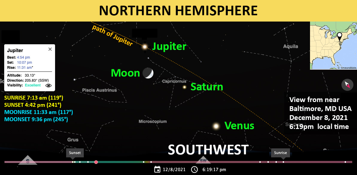
MAP CREDIT: TimeandDate.com
Here is what it looked like in real life. It’s dark outside (and mostly cloudy). The sunset was at 4:42 pm (the earliest of the year)! This photo was taken at 6:19 PM. The photo lighting has been tweaked to better show the planets.
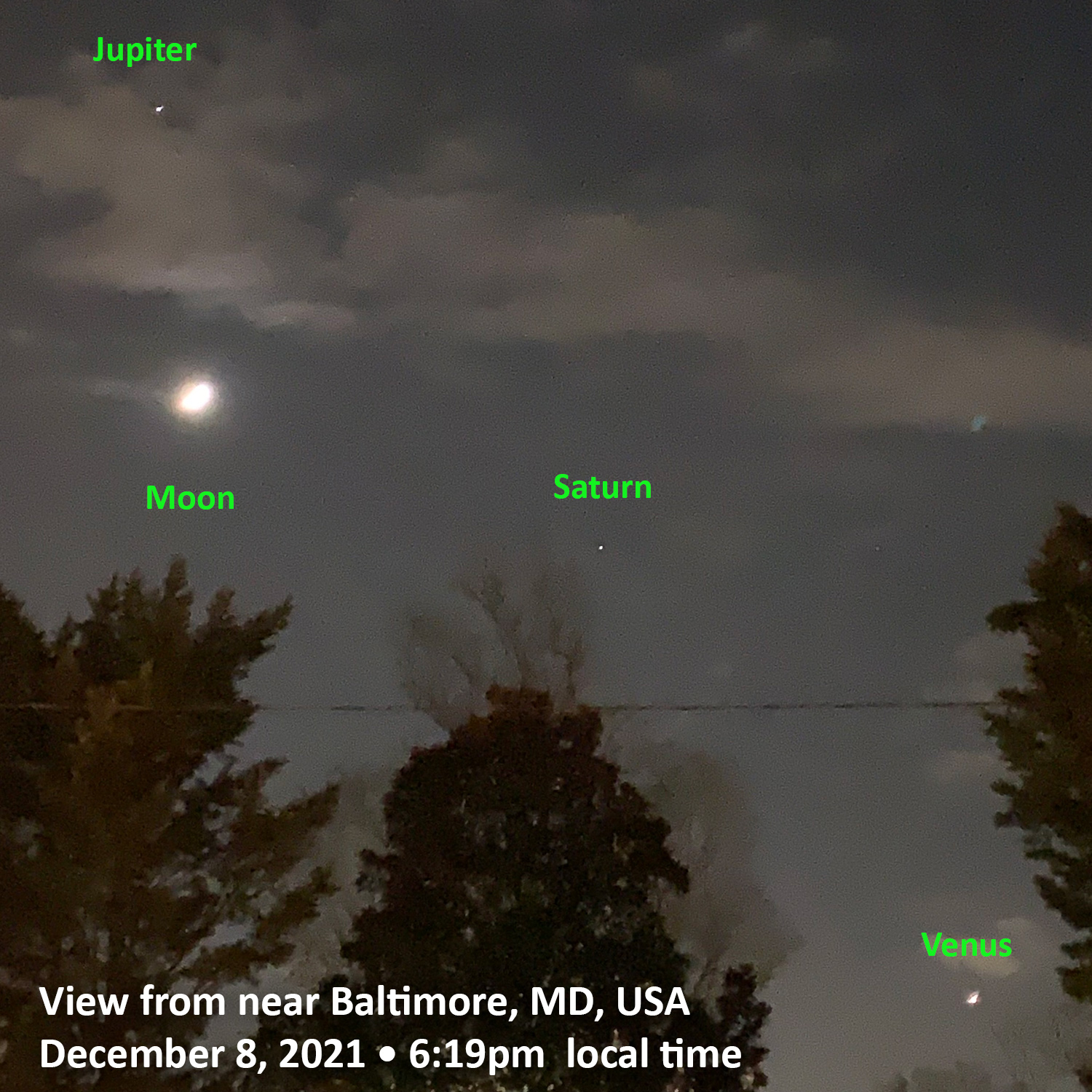
Northern Hemisphere Night Sky – 12.08.2021 – CREDIT: Linda Schenk
If we look on the same day just after sunset in the Southern Hemisphere between the tip of South America and Antarctica, the sky would appear different, flipped. Now Venus is below and to the left of the Moon. Saturn is just below the Moon and Jupiter is below and to the right. We can also see the constellations are flipped with respect to the ecliptic line. Here’s how the map was made.
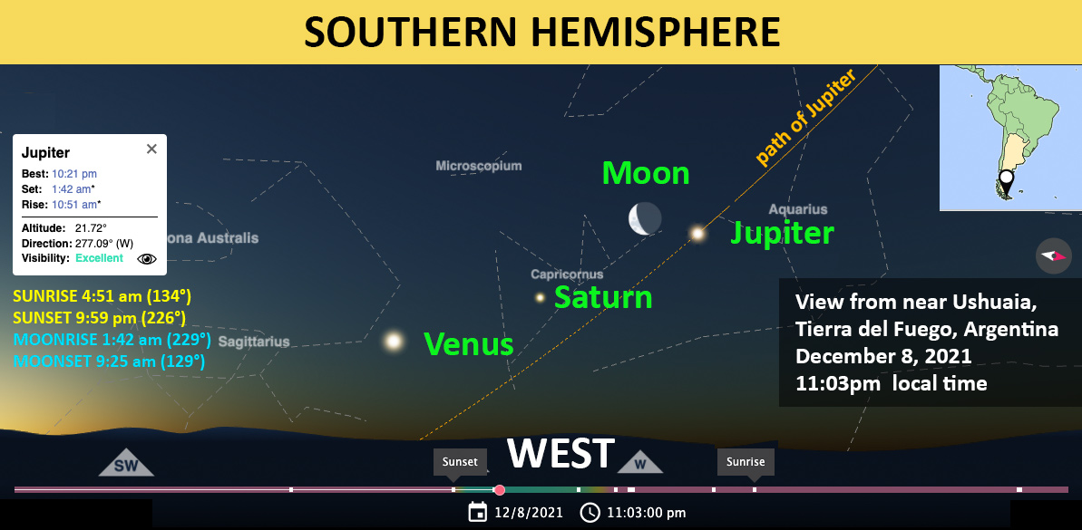
MAP CREDIT: TimeandDate.com
We can see this exact alignment if we look at this photo taken from a ship returning from the December 2021 Antarctic eclipse. This image was taken at the exact time as the picture above from a similar location. Notice that the sunset was at 9:59 pm (the latest of the year)! It’s not completely dark outside, even though it’s 11:03 PM. A future post will explore the geometry of this, comparing locations. Stay tuned.
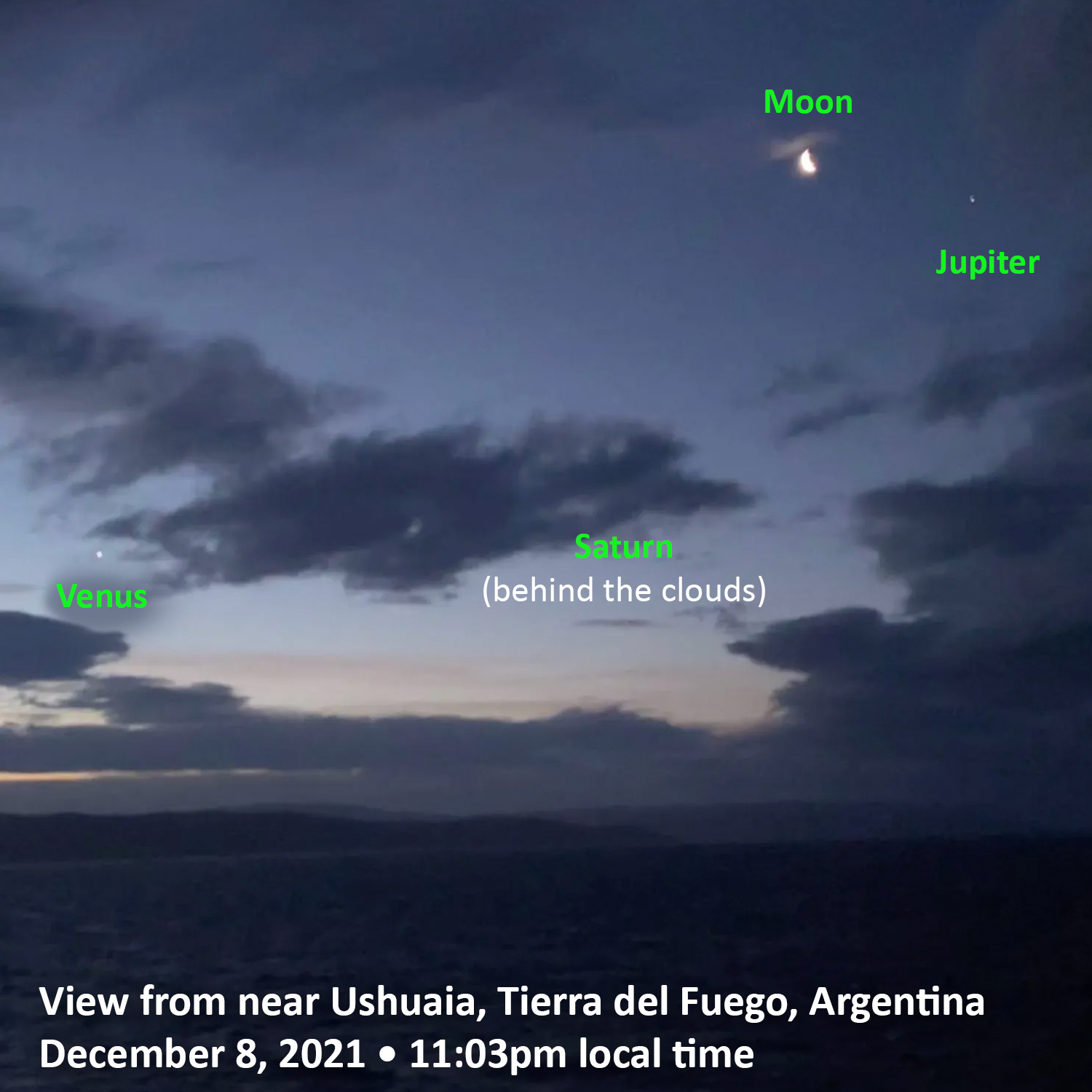
CREDIT: C. Alex Young
Wow! Geometry is cool and we live on a spherical or globe-shaped planet Earth.
 The calculations & observations would only be possible if the earth was not flat like a pancake!
Another fun thing to look for is the International Space Station!
Find ISS viewing times here – you can get alerts for when it’s above the tree line. However, on this night of looking for the planets, it completely surprised me, a minute after taking some photos. I only had about 3 minutes total with no clouds! A neighbor & I were looking at this and we noticed a small bright dot about the size of the planets moving towards the left, right through Saturn, then into the clouds. My Star Walk app confirmed it was the ISS!! What a fun surprise!!
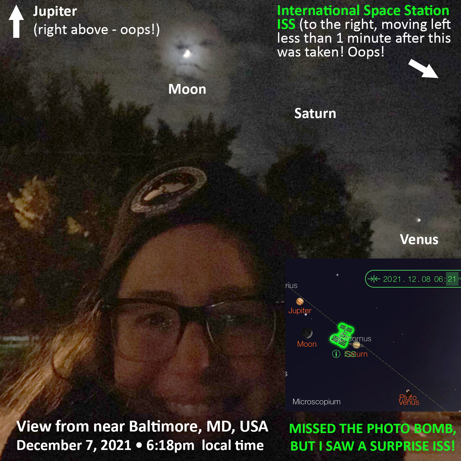
12.08.2021 – Just missed an ISS photobomb! CREDIT: Linda Schenk & the Star Walk App


